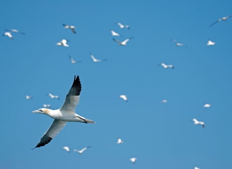
The history of Track a Gannet (T.A.G.)
In 2015 Alderney Wildlife Trust started an exciting project to help give us an amazing insight into the lives of our Northern Gannets, T.A.G. - Track a Gannet. We fitted miniature GPS tracking devices that use the mobile phone network to transmit the positions of the gannets, monitoring their daily movements.
Alderney’s Northern Gannet colonies are the second most southerly in the world and support around 1% of the species’ population. With many offshore wind farm sites proposed within the English Channel and with the possibility of tidal turbines being deployed in Alderney’s waters, it is more important than ever for us to understand where these magnificent birds are feeding and migrating. The information gained from the tags gave an unprecedented picture of the gannets’ life-cycle, feeding habits and the likelihood of their interaction with potential offshore wind farms and tidal developments.
The AWT raises funds every year to purchase state-of-the-art experimental miniaturised GPS tracking devices which were placed on the birds' tail feathers by a team of scientists from the British Trust for Ornithology, Liverpool University and the AWT. The tags last around six weeks, which is ideal as we do not want these devices permanently attached to the birds. Your support allows us to carry out this research on Aldereny's gannets and we would not be able to run the project without it.
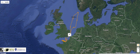
Gannets can fly several hundred kilometres in a single foraging trip. In 2015 the maximum distance we recorded for a single trip was over 800km - that's past Canterbury. But this was dwarfed by Cosmo's trip in 2016 (left), almost to Norway and back in under a week. This is a round trip of over 1700km and a new record for the species!
Geolocation
In July 2017 we put 10 geolocators on the colony of Ortac as part of the T.A.G. project
The geolocators weigh just 1g and are about half the size of a penny, attaching to a colour ring on the Gannets leg. For such small pieces of technology they are quite sophisticated, containing a battery (lasting up to two years), small computer, clock and memory. They use light levels to work out the geographical location of the bird by looking at light levels throughout the day, which can determine latitude and longitude. The data is then stored and will, once downloaded, create a map of where the birds have been. Temperature is recorded, which can help find the altitude birds are flying and pinpointing the birds location more accurately. Finally the geolocators record wet/dry and conductivity, showing whether the water is salty so how much time the birds spend on the coast salty (not so useful for Gannets which do not fly over land) and how long the birds are spending on the water.
The geolocators last up to two years gathering data. In summer 2019 and 2020 we recaptured birds fitted with geolocator from 2017. Finding the birds with geolocators may sound like hunting for a needle in a haystack but is not as difficult as it may sound! The geolocator-fitted Gannets have bright colour rings which are fairly easily spotted on the colony.
The 10 sponsors of our geolocators named their birds and the class of 2017 was Saoirse, John, Wilf, Hector, Prospero, Figaro, Mercury, Lysander, Quetzalcoatl and Minnie. You can see the maps for Soairse (found in 2019) and Lysander (2020) below.
We added ten new geolocators to gannets on Ortac in 2020 and will look to retrieve them in 2021/22
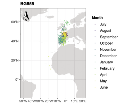
Saoirse the gannet spent the majority of its time in the Mediterranean and Bay of Biscay, not travelling too far south.
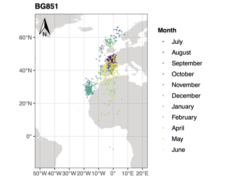
Lysander spent its time much further south. It's final destination was noteworthy as, so far, only one Gannet ringed as a chick at the Channel Island colonies has been recovered as an adult off west Africa. This is despite 50+ years of chick ringing there, and suggests the geolocators may reveal that more of Alderney's adult Gannets winter off west Africa than previously thought. However, to be sure we need to recover more - and this will be our focus next year.
©Joshua Copping

